South America trip, days 8-10
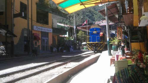
We rose early to catch the train to Aguas Calientes, which is the main tourist town near Machu Picchu. The rail runs from Cusco-Ollantaytambo-Aguas Calientes, and is a great way to get to the town. We had to show our passports to get on, but once on the train is a comfortable glass-roofed affair, definitely worth it for the 1hr 45 min travel time. The train followed the river through the mountains, past some snowy peaks, some with cloud pouring over them. We made one brief stop to drop off passengers doing a leg of the Inca Trail, and arrived at Aguas Calientes shortly after.
Aguas Calientes (literally, “hot waters”- I’ll explain why in a while) is a very touristy town, 2000m above sea level, with one main purpose: get people to Machu Picchu. The best comparison someone made was a ski town. We walked up to our hotel (A rabbit warren of a building) and then had the whole day to kill, so we decided to have a nice and relaxing fucking dangerous climb up a mountain.
Our tour leader, Maruja, had shown us a picture from one of the Inca trail guides of a track near Aguas Calientes that is supposed to give a great view of Machu Picchu from another angle. Sure, we thought, a 2 hour hike up, a ladder or two, it’ll be great.
Wrong.
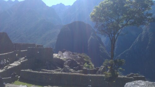
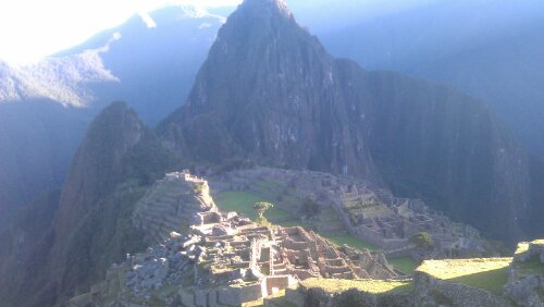
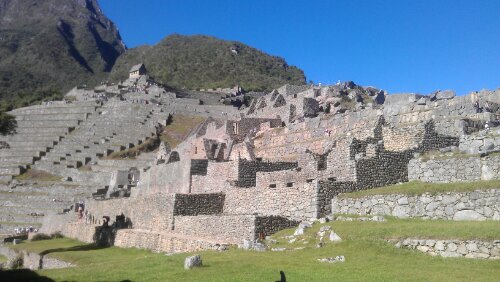
Putucusi, as the mountain is called, rises 5-600m from Aguas Calientes. It is the hardest walk I’ve ever been on. That’s it in the top photo up there as seen from Machu Picchu.
Let me explain why. Aguas Calientes and Machu Picchu are lower than Cusco, meaning it is wetter and more jungle like. This meant for the first half of the hike every step is slippery. The hike itself is a former Inca track, so it is stepped, but half of those stairs have eroded away and the rest are either slippery, steep, or a combination thereof. In the areas where there has been a rock slide or a significant chunk of the track is missing, the Peruvian authorities have installed wooden ladders.
The first of these ladders, encountered 15-20 minutes in, is about one hundred rungs going up about 30 metres, with a 40 rung and 60 rung ladder not too far after. Did I mention that we’re in a rainforest? That makes all two hundred rungs damp and slippery. If we’d had a rainy day, the walk would be impossible. If you fell off, especially on the first ladder, that’s pretty much it.
Splat.
(This video, not mine, gives you an idea of the first ladder)
About halfway up it gets if not easier, then a nicer kind of hard. You exit the rainforest and enter a dry section, where you can see back down to Aguas Calientes. And into a neighbouring valley. It’s still steep, but you no longer feel like you’re going to die if you fall. There’s a point where you begin to see into a neighbouring valley, and you can hear different parts of the river around each turn.
After Pisaq and Ollantaytambo I had begun to fell sorry for the Inca, but trudging up those stairs all my sympathy was lost. Any civilisation that willingly builds trails like this and even entertains such bollocks deserves everything the Spanish did to them.
I kid. Mostly.
After climbing for what seemed like forever, I reached the top of Putucusi in about 1hr 40min. I’m pretty happy with that, given that the mountain goats in the group did it in about an hour 20 and the stragglers in over two hours.
The view from the top was pretty incredible. We could see the whole Machu Picchu complex, from the Sun Gate to the top of Wayna Picchu (I’ll discuss this later in this entry). I took a number of great pictures (on my camera, so not shown here) and we took a few group shots at the top. After eating our lunch, recovering our breath, we began our slow descent.
The ladders on the way down are a lot harder, especially when you’re sore and jelly legged. I did only slip once, and it was a slow fall in a safe area, so we all made it back alive. Not intact- we were all bruised and sore for several days after, but alive.
Aching, most of the group decided to find the Hot Waters the town is named for. Aguas Calientes is the site of natural hot springs, and these have been tapped for some public baths. For 10 soles, we walked through a pretty path to the main baths, which were warm but not hot. There were cold showers to heighten the impact of the baths, and they were quite soothing after our unexpectedly difficult trek.
I do not want to speculate, given the colour of the water, how many people use the springs per day.
Out to tea at a Mexican restaurant, which was pretty terrible and we’re pretty sure has lead to the crook stomachs of half the group (myself included), then an early night for our trip to Machu Picchu.
We woke up at 4:30 for a 5:10am departure to the Machu Picchu buses. Legs, very sore. The way the system works is that there’s no access to the site other than through the bus system or walking up the hill; there’s no carpark at the top. We got on one of the first buses and began our climb up the switchbacked road (that we could see the day before, except the buses looked like matchbox cars from where we were). We arrived at the gate to Machu Picchu just as it was getting light in the sky, and met with our G-Adventures guide, Andre. Andre led us up a set of stairs (not actually that steep, but hellish after the day before) to a vantage point where we could watch and photograph the sun rising over the ruins.
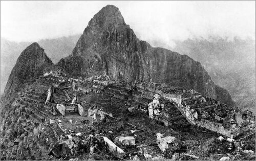
The “discoverer” of Machu Picchu was Hiram Bingham, a Yale scholar who in 1911 was looking for the fabled city of El Dorado. Story goes that when he was close to the site he paid a boy to show him the way, and there were two families actually inhabiting part of the site. Bingham’s original photograph show the site in a high state of decay, overgrown and partially collapsed in places. The vegetation has of course been mostly cleared, and some of the buildings have been partially re-assembled to get the site closer to its original state.
This copy of the Bingham photo I found here
We walked from our vantage point into the site, to an area where we could see the Temple of the Sun. I mentioned in the previous entry that Inti was the number one god of the Inca in their heyday, and the temple of the sun was very important. This is evidenced by the nature of its construction- smooth, precisely chiselled stones that form a curve, rather than the still well-built but less uniform buildings present in much of the rest of the city. We went up to the top of the site, where the Inca have a stone representation of the Southern Cross.
Chakaya, as the Southern Cross was known to them, is a central part of Inca philosophy. The actual Chakaya figure is this:
Forgive the crudity of my drawing
The figure has multiple meanings. First, the three steps on each side represent the three Inca worlds: the underworld, Uku Pacha (represented by the snake), Kay Pacha, the material world (represented by the Puma), and Hanan Pacha, the heavens (represented by the condor). The 3 steps can also signify the three Inca laws, which are: don’t kill, don’t steal, and don’t be lazy. If you draw a line through the middle of the cross, you get the duality between night/day man/woman yin/yang, and the cross is sometimes seen in quarters each quarter representing one of the four Inca kingdoms (Machu Picchu perhaps being the capital of one of them) and the capital, Cusco, in the centre.
We walked through the observatory and down again, near to Wayna Picchu. Wayna Picchu is the mountain behind the city site (that you can see in the photo above- the actual “Machu Picchu” mountain is where most of the photos including that b&w one are taken), and from there we could see a sacred stone that the Inca had carved to match the profile of a nearby mountain, who were worshipped as protectors. You can climb Wayna Picchu, by the way, but it a) costs money, b) is limited to 400 visitors a day and c) was never going to happen the day after Putucusi.
We continued through a residential district to the temple of the condor, which has a condor carved into the floor and walls behind it. We also visited the King’s house, which is a bit better built than peasant quarters but not near the quality of the temples. The king’s house had something special that no other residential quarters had: a draining toilet (most Inca were stuck with latrines).
We ended up spending about 5 hours at Machu Picchu. It’s truly an amazing place.
We caught the bus, the train, then another bus back to Cusco, glad to be at a place where we could get our washing done. We ate at a simple Chinese restaurant next door to the hotel (deciphering a Chinese menu in Spanish is an interesting exercise) and collapsed into bed.
The next day we had free to look at and do all the stuff we didn’t do the first time in Cusco. Karlee and I decided to do a souvenir run in the tourist market, where the prices are always “special for you senor” (sure) and “all genuine Alpaca” (yup). We wandered up to the main square of Cusco to look at the Cusco cathedral. The cathedral, like most buildings of note in Cusco, was built on the foundations of Inca sites, but has been a Cathedral since about 1600. The Cusco people have a local relic they call the “lord of the tremors” (also the “black Jesus” due to its discolouration) which is said to have protected the cathedral from destruction in the 1650 earthquake.
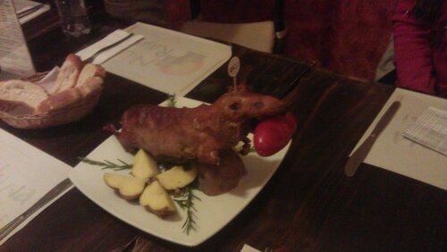
The article in the cathedral is all of the “Cusco school,” religious pieces painted by Peruvian artists. While many of the pieces followed the lead of Spanish and Italian artists of the time, there are some local touches: in a painting of the Last Supper, Judas looks suspiciously like Pizarro, and Jesus and the Apostles are sharing a guinea pig as their meal.
Speaking of, we went out to tea that night to celebrate our last night in Peru:
Tastes a little like duck.
Stray observations
– Peru are big on passports- you need to show one to get on the train, into Machu Picchu, a couple of other places. I did get a cool souvenir passport stamp from Machu Picchu.
– Apparently our tour leader has been getting looks of disbelief whenever she mentions that she took a group up Putucusi.
– Tour Joke: in most countries, when you sneeze, you say the equivalent of “good health!” In English, it’s “bless you.” So, whenever anyone sneezes, “health!”
– More Quechua: I mentioned in the last entry that Incas called themselves Tawantinsuyu. What it actually means is more like “four kingdoms under Inti.” the four kingdoms are Chinchansuyu, which is northern Peru and Ecuador, Cuntisuyu, which is between Cusco and the coast, Antisuyu, Northwest of Cusco in the high Andes, and Qullasuyu, which covered chunks of Bolivia, Chile, and Ecuador.
– Fun fact: the Inca never invented the wheel. They had rollers, but no wheels.
Next up: Lake Titicaca!
